tampaBayOpenData
An R Interface to Tampa Bay Public Open Data
Provides a lightweight R interface for discovering and retrieving public 'ArcGIS' datasets across the Tampa Bay region. Search civic datasets and load records directly into R without manually navigating separate portals, constructing REST API requests, or handling pagination. Supports public data published by the City of Tampa, City of St. Petersburg, City of Clearwater, Hillsborough County, Pinellas County, and Tampa Bay Regional Planning Council. Discover layers in these and other public 'ArcGIS' portals and retrieve them by their REST URLs. A publisher registry configures discovery, while a separate dataset registry identifies layers checked by package maintainers. Filter catalogs by source, geometry, topic, category, and modification date. Retrieve queryable layers with validated pagination, bounded previews, server-side filtering, typed tabular results, optional spatial objects, and source provenance. Save large downloads as local chunks that can be validated and resumed. Designed for analysts, researchers, students, journalists, and civic technologists who work across separate public data portals. Public source pages are the City of Tampa GeoHub < https://city-tampa.opendata.arcgis.com/>, St. Petersburg ArcGIS portal < https://csp.maps.arcgis.com/home/index.html>, Clearwater ArcGIS portal < https://cityofclearwater.maps.arcgis.com/home/index.html>, Hillsborough County GeoHub < https://hcfl.gov/about-hillsborough/open-data-and-gis/geohub>, Pinellas County Enterprise GIS < https://new-pinellas-egis.opendata.arcgis.com/>, and Tampa Bay Regional Planning Council GeoHub < https://opendata-tbrpc.hub.arcgis.com/>.
tampaBayOpenData


tampaBayOpenData provides a lightweight R interface for discovering and retrieving public ArcGIS datasets across the Tampa Bay region. The package lets users search for civic datasets and load them directly into R without manually navigating ArcGIS portals, constructing REST API requests, or handling pagination themselves.
It currently supports public data published by:
- City of Tampa
- City of St. Petersburg
- City of Clearwater
- Hillsborough County
- Pinellas County
- Tampa Bay Regional Planning Council
Designed for analysts, researchers, students, journalists, and civic technologists, tampaBayOpenData provides a consistent workflow across ArcGIS publishers that otherwise expose data through separate portals and services.
Install
Install from GitHub:
install.packages("pak") # if needed
pak::pak("Jaclenga/tampaBayOpenData")
Install sf as well if you need spatial results.
Find and retrieve a checked layer
library(tampaBayOpenData)

parks <- tbod_search_datasets("parks", source = "checked")
parks[, c("id", "title", "publisher")]

data <- tbod_get_dataset("stpete-parks", limit = 100)
tbod_provenance(data)[c("publisher", "source_url", "retrieved_at", "complete")]
The search reads the bundled catalog; retrieval contacts the publisher.
limit = 100 returns a subset, recorded as incomplete in its provenance when
more records match. Omit limit to request all matching records, subject to
the service and package limits described in the retrieval guide.
A checked layer has a catalog entry and a saved field, geometry, and CRS snapshot. Before retrieval, its live metadata is compared with that snapshot: compatible changes warn; incompatible changes stop the request. Checked status does not verify individual records or guarantee the service will remain available. See schema checks and retrieval.
Search beyond the catalog
Live discovery searches the six configured ArcGIS publishers. For example,
tbod_search_datasets("housing", source = "live", portals = "city") searches
Tampa's portal. To search another public ArcGIS portal, supply its sharing
REST root:
# Replace this address with the public sharing REST root of your portal.
other <- tbod_discover("https://example.maps.arcgis.com/sharing/rest",
                       query = "parks")
if (nrow(other)) tbod_get_dataset(other[1, ], limit = 100)
Portal results have discovered status; rows from a service or layer URL have
not_checked status. Both work with tbod_get_dataset() and have no saved
checked schema. Live searches can miss items when the scan is bounded or a
publisher service fails; inspect attr(other, "discovery_complete") before
treating a result as a complete listing. A direct public FeatureServer/<id>
or MapServer/<id> URL also works with tbod_get_dataset(). The discovery
and retrieval
articles cover filters, scan limits, direct URLs, and downloads.
See spatial data
The checked City of Tampa city-boundary and capital-projects layers can be
retrieved as sf objects with spatial = TRUE.
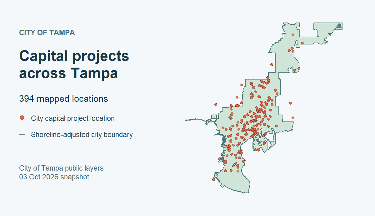
City of Tampa data retrieved October 3, 2026 (both ArcGIS items marked CC0). The shoreline-adjusted boundary is not a legal survey; the points do not establish current project status or complete coverage. Reproduce the map or follow the spatial walkthrough.
Coverage and source limits
The 52 checked layers are selected references, not a complete inventory or uniform coverage of each topic. Publisher services can change, and some layers are active views or approximate boundaries. The TBRPC storm surge layer is a historical planning model, not current emergency guidance. See the coverage guide for publisher counts, layer caveats, and reuse terms, and the catalog policy for selection and maintenance decisions. The package's MIT license covers its code, not the source data. The package is independent of the publishers and rOpenSci.
Citation
Cite the package and the original data publisher and dataset. For the package citation, run:
citation("tampaBayOpenData")
toBibtex(citation("tampaBayOpenData"))
tbod_dataset_info(id) gives catalog source details;
tbod_provenance(result) records the retrieval source and time.
Learn more
- Get started and function reference
- Discovery, retrieval and downloads, and coverage and provenance
- Developer document index, architecture, API migration, validation, and contributing
- Packaged bicycle network example (R Markdown) (offline by default; optional small live subset), and the full-data bicycle network exploration (live analysis)
- Short R data exploration stories across six publishers